Anyway, I left from St John's and drove down the Southern Shore Highway until I reached Horsechops Road, just before Cape Broyle. The word 'road' in Horsechops Road is used very loosely given that I'd call it more of a track with a ridiculous amount of pot holes but it's still better than walking from the highway. I drove in as far as my car could physically take me before continuing on foot.
By this time, it was well into the evening and as I walked into the AWR, it was getting dark. My aim was to reach Mount Carmel Pond and find somewhere to put the tent up there. Enroute, a rather grumpy looking fellow travelling in the opposite direction to me took it upon himself to ask me where I was going and then put another dent in my morale by exclaiming "you've got a fair ways to go yet!". I was swearing under my breath as he drove off on his quad bike.
Finally, as it was getting almost "properly dark", Mount Carmel Pond was in front of me. This is another weird Newfoundland thing. A pond to me is something in someone's back garden. This thing was like a gigantic loch. Anyway, whilst being eaten alive by various flying objects in the dark, I found a spot to get the tent up, drank some beers that I'd lugged in with me and fell asleep.
 In the morning, I surveyed the area for the first time in daylight and this photo shows where I put up my tent (one-man). This area appears to be fairly well used by campers given the stump/seat that someone has made and of course, the litter and beer cans that were lying around (none of mine!). Thankfully, I was the only person around while I was here.
Once I had some breakfast, I left the tent, took a small bag and continued along the same track (Horsechops) as it basically goes right in the AWR. I was hoping to see some caribou but unfortunately, there wasn't a single living thing to be seen - well, nothing that runs, flies or bites anyway.
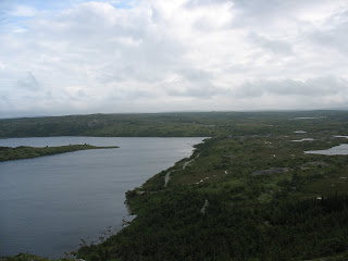
After I felt that I'd had enough of the track, I went cross-country over to a wee hill to get a better look at the surroundings. These photos are typical of what I saw in either direction.

 Once I'd had my fill of the scenery, I decided that I couldn't really be bothered walking much further into the AWR. Well, there was that and the fact that the weather was closing in with fog and rain so I wanted to make it back to the track as soon as possible and start back to the tent. On the way back, I decided there was no need to stay another night and further exploration would require walking in WITH the tent. I got back to the tent about mid-afternoon, so I decided to pack up and continue on to the car and home.
Overall, it was a worthwhile trip but I needed more time to really expore the place. This trip was just to get a feel for it. Maybe next time, I'll go in further and maybe walk right across it.